Serious gaps in Baseline Traffic Data
Low Traffic Neighbourhoods are intended to reduce traffic and are usually put in place with an Experimental Traffic Order. At the end of an 18 month trial period a document called a Final Monitoring Report is prepared, and this forms the basis for Council decisions on whether to keep a scheme in place or remove it. A key comparison within a Final Monitoring Report is the amount of traffic passing count locations before a scheme is put in place compared with the count at the end of the 18 month trial. Traffic measurements are also relevant for designing a scheme and this includes data on “turning movements”. For much of the area traffic count data was provided in the scheme documentation, but our transport consultants identified some serious gaps in traffic counts and turning movements data.
The transport consultants say: “We note that Haringey officers have requested the following information and reasonings:
- Hourly Traffic Data: We are interested in obtaining hourly traffic data for the area. This data will help us analyse traffic patterns and assess the impact of the proposed changes in Haringey.
- Turning Movements: Detailed information on turning movements at key intersections within the proposal area would be greatly appreciated. This will assist in evaluating traffic flow and safety
- considerations.
- Current Designs: If there are any preliminary designs or drafts available for the Dartmouth Park proposal, we would like to review them to provide informed feedback.”
So it was not just us saying the data was inadequate. The traffic consultants had the same opinion, and so did the Haringey transport planners! As this scheme moves forward, these gaps must be filled.
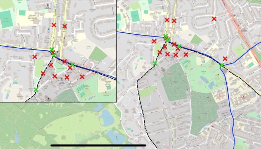
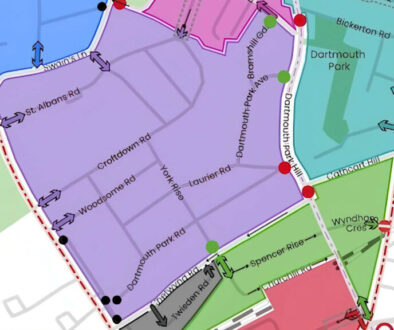
A detailed list of gaps has been notified to the Camden Safe Travel team and is shown on the maps below. The red marks show traffic counts required and the green marks the turning movements data needed.
Monitoring reports typically look at traffic on internal and boundary roads, but research has suggested that traffic restrictions in an LTN can affect external roads beyond the boundary of a scheme. Archway Road and North Road / North Hill are examples of external roads that could be affected by the Dartmouth Park Healthy Neighbourhood scheme.
An earlier study for the Dartmouth Park area, which we obtained through a Freedom of Information request, used data from an organisation called “The Floow” which uses telematics technology (measuring devices used in vehicles). Although not fully accurate this data provides a general overview of the usual traffic conditions. During the evening peak, traffic volumes on Archway Road were around 1,000 vehicles an hour in each direction but interestingly were higher on Highgate High Street and North Road. During the morning peak, both roads have similar volumes though with the short stretch of Highgate High Street between the junction with West Hill and with Hampstead Lane just slightly higher. Hampstead Lane and Gordon House Road could also be affected by traffic changes.
Traffic counts are only a crude way of measuring the disturbance created by vehicles. Archway Road may not have a greater number of vehicles but it definitely has a much greater proportion of HGVs, which are not permitted in Highgate High Street other than for access.
See Camden May 2021 baseline analysis See pages 48 to 51 and 54 to 56 which shows modelled flows on Archway Road and the other roads mentioned.
It is essential that comprehensive measurements of traffic are obtained before any scheme is put in place and should include the main external roads, as well as internal and boundary roads.
